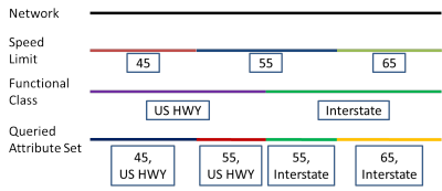
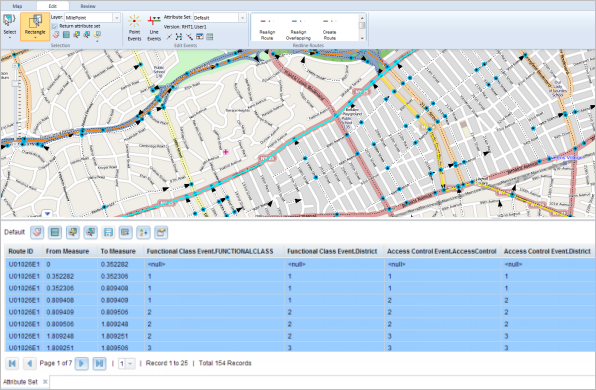
The Return attribute set option on the ArcGIS Event Editor allows you to return a selection result as an attribute set, where each layer of the attribute set is dynamically segmented together into one record set.

Using the Return attribute set option on a network layer will return records separated at any measure along that network where any of the preselected attribute set events change. On a point event layer, this option returns the attributes for the entire selected attribute set at each point event. On a line event layer, this option returns separate records at any measure along the event where any of the preselected attribute set events change.
Use the following steps to return attribute sets for networks, point events, and polyline events.
- Open Event Editor and, if prompted, sign in to Portal for ArcGIS or ArcGIS Online.
- Click the Edit tab.
- In the Edit Events group, click the Attribute Set drop-down arrow and choose the attribute set you want to use.

- Click the Layer drop-down arrow and choose the network or event layer for which you want to return attribute sets.
Depending on which type of layer you choose, the results of your attribute set will differ.
- Check the Return attribute set check box to ensure an attribute set is returned for your selection.
- Choose a method to select the area of the map for which you want to return an attribute set.
If you have a network or event table open in Event Editor when querying an attribute set, your open table is replaced with an attribute set table of your results.
Nota:
You can only create a new selection when you are selecting an attribute set as result; with the Return attribute set option checked, the selection methods to Add to Current Selection and Remove from Current Selection are disabled.
The selected records are shown in the attribute set table and highlighted on your map.

You can also edit the cells in the attribute set table. The cells in white are editable, while the cells in grey are not. A cell can't be edited if another user, or the same user in a different version of the database, has acquired locks on the event record.
Nota:
If a message appears that is related to acquiring locks, the inability to acquire locks, the need to reconcile, and so on, Roads and Highways conflict prevention is enabled in ArcGIS Event Editor.