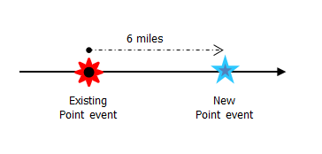
Characteristics of a route can be represented as a point event located using an offset distance from an existing point feature. The reference offset data is translated to routes and measures for storage. As shown in the example below, imagine a route with From and To measure values of 0 and 12 miles, respectively. The Measure of the event is located at a distance of 6 miles to the right of the existing point feature.
If the calibration direction of the route was from right to left, the offset distance would have been calculated in the reverse direction (from left to right). In that case, the offset distance would have been shown as a negative number. 
- ArcGIS Event Editor を開き、サイン インが要求されたら、ArcGIS 組織にサイン インします。
- [編集] タブをクリックします。
- In the Edit Events group, click the Point Events button
 .
.The Add Point Events widget appears.

The widget is unavailable when there are no editable point event layers in the map.
- [イベント レイヤー] ドロップダウン矢印をクリックし、編集するイベント レイヤーを選択します。
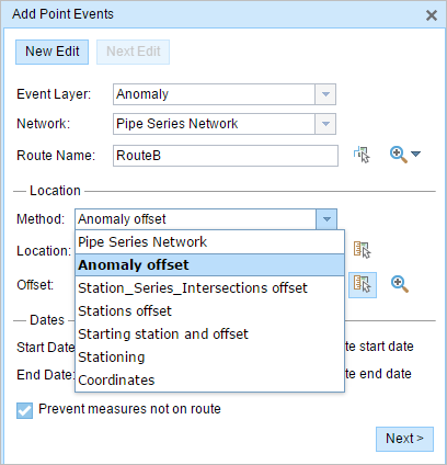
- In the Location section, click the Method drop-down arrow and click Anomaly offset (Point Event layer name with offset suffix).

All the point event layers that are published with the map service and are registered with the chosen network appear in the drop-down list.
- [ネットワーク] ドロップダウン矢印をクリックし、新しいイベントのメジャー値のソースとして使用されるネットワークを選択します。
- ウィジェットは、新しいポイント イベントを追加するロケーションを特定するためのソースとして、LRS ネットワークを受け入れます。 しかし、新しいポイント イベント データがデータベースに格納されている場合、アプリはメジャーを内部的に変換し、常にイベントが登録されている LRS ネットワークのリニア リファレンス方法 (LRM) にメジャー値を格納します。
- [ネットワーク] 値には、公開された LRS ネットワーク レイヤーを使用できます。
- 次のいずれかのオプションを使用し、新しいイベント メジャーのもととなるルート名を選択します。
- [ルート名] テキスト ボックスにルート名を入力します。
- [マップ上でルートを選択] ツール
 をクリックし、マップ上のルートを選択します。
選択されたルートが、マップ上でハイライト表示されます。
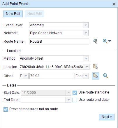
- Provide the Offset value for the reference offset using any one of these options:
- Click the Direction drop-down arrow and choose the direction of the offset, type the offset value, and choose the units.
- Type the Offset value and choose the units.
- Click the Select an Offset Location on the Map tool
 and select a location along the route on the map.
A red x is placed at the offset location along the route on the map. This is the location of the Measure value for the event.
注意:
- This value denotes the distance between the chosen point event and the proposed Measure on the selected route.
- The offset direction is optional.
- If no direction is specified, a positive offset value will place the Measure location along the direction of calibration from the selected point feature, and a negative offset value will place the Measure location opposite the direction of calibration from the selected point feature.
- The new event will be associated with the route (route name) from the LRS Network that the event location intersects. In cases where the input location intersection may have more than one route in the registered LRS Network (overlapping routes), a dialog box prompts you to choose the route with which you prefer the event to be associated.
- If you type the Measure value, you can choose the unit for that value using the drop-down arrow. The Measure value will be converted into the LRS units before saving the newly added events. For example, the LRS is in miles and you have entered 528 feet as the Measure value. The newly added events will have a Measure value of 0.1 miles because 528 feet equals 0.1 miles.
- 次のいずれかの操作を実行し、イベントの開始日を定義する日付を選択します。
- [開始日] テキスト ボックスに開始日を入力します。
- [開始日] ドロップダウン矢印をクリックし、開始日を選択します。
- [ルート開始日を使用] チェックボックスをオンにします。
開始日のデフォルト設定は当日の日付ですが、日付ピッカーを使用して別の日付を選択することもできます。
注意:
Event Editor インスタンスで、ルートの開始以前の日付を許可しないよう構成し、選択したルートの開始日以前の日付を [開始日] に入力した場合は、選択したルートの開始日当日、またはそれ以降の日付を選択するよう警告するメッセージが表示されます。
- 次のいずれかの操作を実行し、イベントの終了日を定義する日付を選択します。
- [終了日] テキスト ボックスに終了日を入力します。
- [終了日] ドロップダウン矢印をクリックし、終了日を選択します。
- [ルート終了日を使用] チェックボックスをオンにします。
終了日は任意です。指定しなければ、イベントはこれから将来にわたって有効であり続けます。
- [ルート上にないメジャーを使用しない] チェックボックスは、デフォルトでオンになっています。
[ルート上にないメジャーを使用しない] - このデータ検証オプションを使用すると、開始メジャーと終了メジャーの入力メジャー値が、選択されたルートの最小メジャー値と最大メジャー値の範囲内にあることが保証されます。
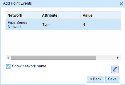
- Click Next to view the Attribute-Value table. This table contains all the attributes of the event layer. Fill in all the attribute information for the new event in this table. Check the Show network name check box to see the LRS Network with which the selected event layer is associated.
The attribute table appears.

ヒント:
[属性値のコピー] ボタン
 をクリックして、マップ上の同一のイベント レイヤーに属する既存のポイント イベントをクリックし、そのポイントのイベント属性をコピーできます。
 - [保存] をクリックします。
新しく追加されたポイント イベントが保存されると、右下に確認メッセージが表示されます。 新しいポイントが作成され、マップに表示されます。
イベントが正常に作成されると、次の 2 通りの方法でルートの特徴付けを行えます。
- [新しい編集] をクリックして、ウィジェットのすべての入力内容を消去し、ジオデータベースからテーブルにデフォルト値を復元します。
- [次の編集] をクリックして、ウィジェットと属性セットの既存の入力をすべて維持し、同様の特徴の素早い編集と利便性を確保します。