Доступно с лицензией Location Referencing.
Intersection offset
Characteristics of a route can be represented as a point event offset from an intersection. The reference offset data is translated to routes and measures for
storage.
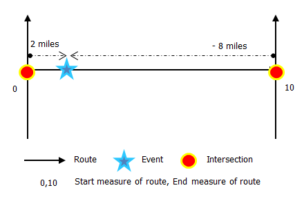
As shown in the example below, imagine the route has start and end measure values of 0 and 10 miles, respectively. The event shown in the figure can be located at a distance of 2 miles from the intersection on the left or at a distance of 8 miles from the intersection on the right. Since the direction of calibration of the route is from left to right, the offset distance is calculated in the reverse direction (from right to left). Hence, the offset distance in the second case is shown with a negative number. Alternatively, the start measure could have been located by an offset distance of 6 miles from the intersection on the left.
- Откройте ArcGIS Event Editor, и, если необходимо, выполните вход для учетной записи организации ArcGIS.
- Щелкните вкладку Редактировать.
- In the Edit Events group, click the Point Events button
 .
.The Add Point Events widget appears.

If there are no editable point event layers, the widget is disabled.
- Щелкните ниспадающую стрелку Слой событий и выберите слой событий для редактирования.
- Щелкните ниспадающую стрелку Сеть и выберите сеть, которая будет использоваться в качестве источника для предоставления измерения для нового события.
- Виджет принимает Сеть LRS в качестве источника для определения местоположения для добавления нового точечного события. Однако когда новые точечные данные событий хранятся в базе данных, приложение выполняет внутренний перевод измерений, чтобы всегда хранить значения измерения в LRM данной сети LRS, с которой зарегистрировано событие.
- Значение Сеть может быть опубликованным слоем сети LRS.
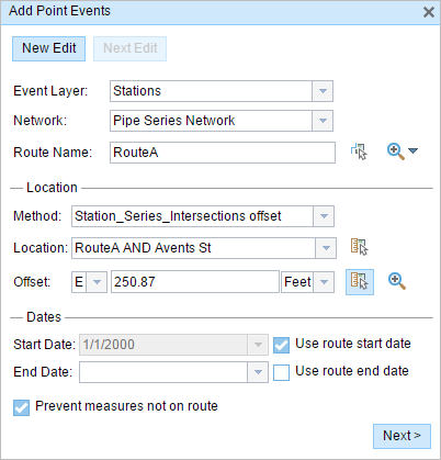
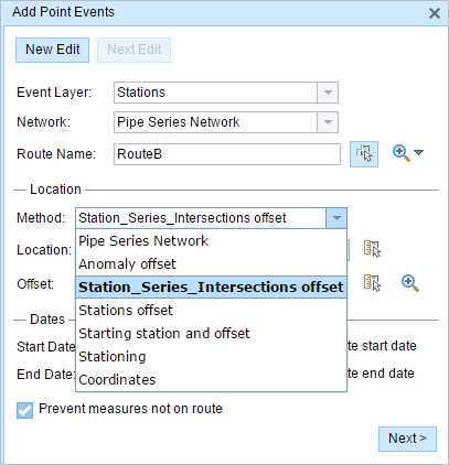
- In the Location section, click the Method drop-down arrow and choose Intersection Offset (Intersection layer name with the offset suffix).

All the intersection point layers that are published with the map service and are registered with the chosen network show up in the drop-down list.
- Choose the Location of the intersection using any one of these options:
- Type the intersection name in the Location text box.
- Click the Select a Location on the Map tool
 and choose an intersection point feature that participates in the layer selected for offsetting on the map.
 - Click the Location drop-down arrow and choose an intersection.
Only intersections that are part of the chosen route can be selected.
- Provide the Offset value for the reference offset using any one of these options:
- Choose the direction of the offset by clicking the Direction drop-down arrow, typing the offset value, and choosing the units.
- Type the value and select the units.
- Click the Select an Offset Location on the Map tool
 and pick a location along the route on the map.
A red x is placed at the offset location along the route on the map. This is the location of the Measure value for the event.
Примечание:
- This value denotes the distance between the intersection and the proposed measure on the selected route.
- The direction is an optional selection.
- If no direction is selected, a positive offset value will place the measure location along the direction of calibration from the selected point feature.
- If no direction is selected, a negative offset value will place the measure location opposite the direction of calibration from the selected point feature.
- The new event will be associated with the route (route name) from the LRS Network that the event location intersects. In cases where the input location intersection may have more than one route in the registered LRS Network (overlapping routes), a dialog box prompts you to choose which route you prefer to associate with the event.
- If you type the Measure value, you can select the unit for that value using the drop-down arrow. The Measure value will be converted into the LRS units before saving the newly added events. For example, the LRS is in miles and you have entered 528 feet as the Measure value. The newly added events will have a Measure value of 0.1 miles because 528 feet equals 0.1 miles.
- Выберите дату, которая будет определять начальную дату событий, выполнив одно из следующего:
- Введите дату начала в текстовом окне Дата начала.
- Щелкните ниспадающую стрелку Дата начала и выберите дату начала.
- Поставьте отметку Использовать дату начала маршрута.
По умолчанию датой начала является текущая дата, но вы можете выбрать другую.
Примечание:
Если вы настроили экземпляр Event Editor таким образом, что даты до начала маршрута недопустимы, а вы ввели такую дату для выбранного маршрута в параметре Дата начала, то появится предупреждение о том с возможностью выбора даты в момент или после даты начала выбранного маршрута.
- Выберите дату, которая будет определять конечную дату событий, выполнив одно из следующего:
- Введите дату окончания в текстовое окно Дата окончания.
- Щелкните ниспадающую стрелку Дата окончания и выберите дату окончания.
- Поставьте отметку для параметра Использовать дату окончания.
Дата окончания является необязательной, если она не задана, то событие останется допустимым сейчас и в будущем.
- Опция Предотвратить измерения не на маршруте отмечена по умолчанию.
Предотвратить измерения не на маршруте — эта опция проверки данных гарантирует, что входные значения измерений для начала и окончания измерения попадают в диапазон минимального и максимального измеренных значений на выбранном маршруте.
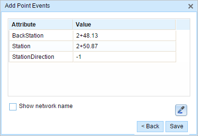
- Click Next to view the Attribute-Value table. This table contains all the attributes of the event layer. Fill out all the attribute information for the new event in this table. Check the Show network name check box to see which LRS Network is associated with the selected event layer.

Подсказка:
Вы можете нажать кнопку Копировать значения атрибутов
 и затем на существующей точке события, которая принадлежит тому же слою событий, на карте, чтобы копировать атрибуты этой точки.
 - Щелкните Сохранить.
После сохранения нового добавленного точечного события в нижнем правом углу появится подтверждение. Будет создана новая точка, она появится на карте.
После того, как точечное событие было создано успешно, у вас есть две опции для дальнейшей настройки маршрута:
- Щелкните New Edit, чтобы очистить все входные данные в виджете и восстановить значения по умолчанию из базы геоданных в таблице.
- Щелкните Next Edit, чтобы сохранить все существующие записи в виджете и наборе атрибутов для удобства быстрого редактирования однотипных характеристик.