Mit der Location Referencing-Lizenz verfügbar.
Using stationing to locate measures
Stationing is the fundamental system of measurement used for pipeline layout and construction. Stations are reference points that are placed along the horizontal measurement of a route
centerline or a baseline at some regular interval. Generally, the distance between two adjoining stations along a route is 100 feet. The first station located at the beginning of the baseline is 0+00, and the next station located 100 feet from it is 1+00. Therefore, a station number of 10+34.05 denotes 1,034.05 feet (10*100 + 34.05) from the starting station.
The station numbers increase from west to east or south to north based on the cardinal direction of the overall pipeline. For pipeline projects, a starting reference station is first established; then all distances along the route centerline are measured from that point location. You can add event data to routes by entering station numbers in the Line Events tool interface. The station data is translated to routes and measures for storage.
You can use the stationing data as an input for adding linear events in the following three scenarios:
- Create a starting or base station on the route and enter the station values as an offset from that station.
- Identify a starting or base station on the route and enter the station values as an offset from that location.
- Use the preexisting stations on the route to calculate or enter the measures in the form of station values.
Using preexisting stations on the route to calculate the measures
You can use this method when stations exist on the route using the Event Editor application. The measures will be calculated using the location and values of the preexisting stations. This functionality is available only for the LRS Networks that contain a Stationing event layer.
In the following
example, there are three existing stations on the route. Stations A, B, and C have station values of 00+00.00, 50+00.00, and 100+00.00, respectively. The stations increase in value
following the direction of calibration of the route, which is from
left to right on the map. The measures on the route are located
by taking these three stations into consideration. The starting measure of the event (station value 18+39.12) is located nearer to the first station (00+00.00) between the first and second (50+00.00) stations.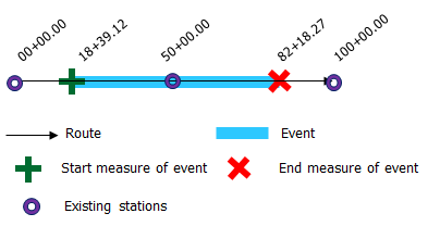
- Öffnen Sie Event Editor, und melden Sie sich bei Ihrer ArcGIS-Organisation an, wenn Sie dazu aufgefordert werden.
- Klicken Sie auf die Registerkarte Bearbeiten.
- In the Edit Events group, click the Line Events button
 .
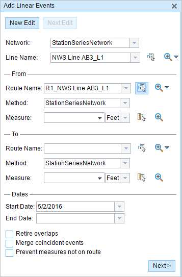
. - Klicken Sie auf den Dropdown-Pfeil Netzwerk, und wählen Sie das Netzwerk aus, das als Quell-LRM zum Definieren der Eingabemesswerte für die neuen linearen Objekte dienen soll.
Das Netzwerk ist ein LRS-Netzwerk, das als Layer in Event Editor veröffentlicht wurde. Sie können angeben, welches LRS-Netzwerk als LRM zum Definieren des Start- und Endmesswertes des neuen linearen Objekts verwendet werden soll. Event Editor akzeptiert auch Messwerte in anderen Netzwerken oder LRMs als den mit dem linearen Objekt-Layer verknüpften.
Das neue Objekt wird mit den Routen (Routen-IDs) aus dem LRS-Netzwerk verknüpft, mit dem sich die Objektposition überschneidet.
- Wählen Sie mithilfe einer der folgenden Optionen den Namen des Linien-Features auf, auf dem sich die Objekte befinden:
- Klicken Sie auf den Dropdown-Pfeil, um den Liniennamen im Textfeld Linienname auszuwählen.
- Klicken Sie auf das Werkzeug Eine Route auf der Karte auswählen
 , und wählen Sie die Linie auf der Karte aus.
Tipp:
Wenn die ausgewählte Linie in der aktiven Kartenansicht nicht angezeigt wird, klicken Sie auf die Schaltfläche Auf die Linienausdehnung zoomen oder den Start- oder Endpunkt der Linie auf der Karte zentrieren
 , um die Kartenanzeige zu aktualisieren und auf die gesamte Ausdehnung der ausgewählten Linie zu vergrößern.
Die Linie wird in Hellblau hervorgehoben. Der Pfeil am Ende zeigt die Kalibrierungsrichtung der Linie an.
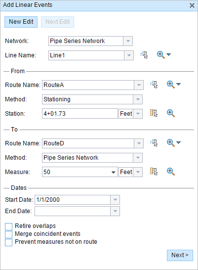
- In the From section, choose Stationing from the Method drop-down list.
- Choose the route on which the event's From measure will be located using the following options:
- Type the route name in the text box.
- Click the Route Name drop-down arrow and choose the route.
- Click the Select a Route on the Map tool
 and select the route on the map.
Only routes that are part of the chosen line can be chosen.
- Using the drop-down arrow, choose the units for station values.
- In the From section, provide the station number using one of the following options to allot the From measure for the event:
- Click the Select a Location on the Map tool
 , and click a location on the selected route. The station number is derived from the route.
 - Type the station number.
A green plus symbol appears at the selected location on the map.
- Click the Select a Location on the Map tool
- You can use separate methods to locate the From and To measures of the events. In the following example, the To measure of the event is located using the route and measure method.
A red x appears at the selected location on the map.
- Wählen Sie mit einem der folgenden Schritte das Datum aus, mit dem das Startdatum der Objekte definiert wird:
- Geben Sie das Startdatum im Textfeld Startdatum ein.
- Klicken Sie auf den Dropdown-Pfeil Startdatum, und wählen Sie das Startdatum aus.
Als Startdatum wird automatisch das aktuelle Datum ausgewählt. Sie können jedoch mit der Datumsauswahl ein anderes Datum auswählen.
- Wählen Sie mit einem der folgenden Schritte das Datum aus, mit dem das Enddatum der Objekte definiert wird:
- Geben Sie das Enddatum im Textfeld Enddatum ein.
- Klicken Sie auf den Dropdown-Pfeil Enddatum, und wählen Sie das Enddatum aus.
Das Enddatum ist optional. Wird dieses Datum nicht angegeben, bleibt das Objekt auch in Zukunft gültig.
- Wählen Sie eine der folgenden Datenvalidierungsoptionen aus, um fehlerhafte Eingaben beim Charakterisieren einer Route mit linearen Objekten zu vermeiden:
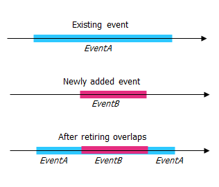
- Überlappungen stilllegen: Das System passt den Messwert sowie das Start- und Enddatum vorhandener Objekte so an, dass das neue Objekt keine Überlappung im Hinblick auf Zeit- und Messwerte verursacht.
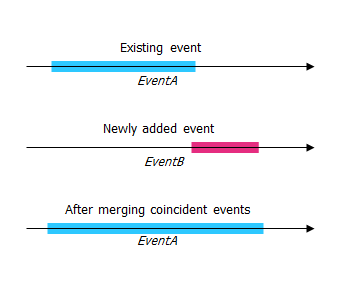
- Lagegleiche Objekte zusammenführen: Wenn alle Attributwerte für ein neues Objekt mit denen eines vorhandenen Objekts identisch sind und das neue Objekt im Hinblick auf die Messwerte an das vorhandene Objekt angrenzt oder dieses überlappt, wird das neue Objekt mit dem vorhandenen Objekt zusammengeführt und der Messwertbereich entsprechend erweitert.
- Nicht auf der Route liegende Messwerte vermeiden: Mit dieser Datenvalidierungsoption wird sichergestellt, dass die Eingabemesswerte für Von- und Bis-Messwerte innerhalb des Minimal- und Maximalbereichs der Messwerte auf der ausgewählten Route liegen.
- Überlappungen stilllegen: Das System passt den Messwert sowie das Start- und Enddatum vorhandener Objekte so an, dass das neue Objekt keine Überlappung im Hinblick auf Zeit- und Messwerte verursacht.
- Klicken Sie auf Weiter.
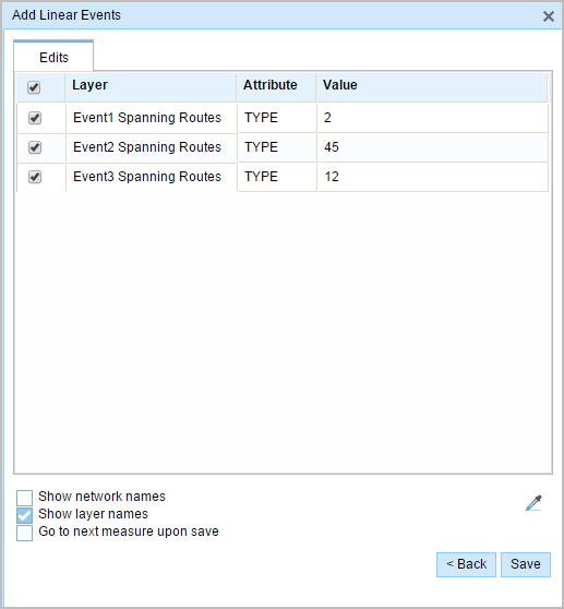
Die Registerkarte mit dem Attribut-Set für die Objekte wird angezeigt.
Hinweis:
Mithilfe der Kontrollkästchen können Sie Daten für spezifische Objekte im Attribut-Set hinzufügen. Deaktivierten Objekten werden keine Datensätze hinzugefügt.
- Geben Sie die Attributinformationen für das neue Objekt in die durch Attribut-Sets definierten Tabellen ein.
Sie können das Werkzeug Attributwerte kopieren
 verwenden, um Objektattribute aus einer anderen Route zu kopieren. Klicken Sie auf das Werkzeug, und klicken Sie auf eine Route auf der Karte, um die Objektattribute zu kopieren.
Event Editor verwendet das auf der Registerkarte Bearbeiten angezeigte Standard-Attribut-Set. Sie können das Attribut-Set ändern, um benutzerdefinierte Attribut-Sets zu erstellen oder das vom Administrator konfigurierte Attribut-Set verwenden.
- Use the following options to access more information on the attribute set:
- Check the Show network name check box to show the LRS Network associated with the selected event layer.
- The list of attributes in the tables defined by attribute sets can be from more than one event layer. If you want to identify the source event layer for each attribute, check the Show layer names check box.
- Checking the Go to the next measure upon save check box results in prepopulating the From measure value using the To measure value of the present section to continue the event creation process.
- Klicken Sie auf Speichern.
Die neuen linearen Objekte werden erstellt und auf der Karte angezeigt. Nachdem die neu hinzugefügten Linienobjekte gespeichert wurden, wird unten rechts eine Bestätigungsmeldung angezeigt.
Nachdem ein lineares Objekt erfolgreich erstellt wurde, stehen Ihnen die beiden folgenden Optionen zur Verfügung, um die Route weiter zu charakterisieren:
- Klicken Sie auf Neue Bearbeitung, um alle Eingabeeinträge im Widget zu löschen und die Standardwerte aus der Geodatabase in der Tabelle wiederherzustellen.
- Klicken Sie auf Nächste Bearbeitung, um alle vorhandenen Einträge im Widget und im Attribut-Set beizubehalten. Auf diese Weise lassen sich ähnliche Merkmale komfortabel und schnell bearbeiten.
Stationing with equation points
If the reference station has both Ahead and Back station values, that implies that at that location along the route, the alignment or measuring has changed. In the example below, there is an equation point along the route where the station values are 1+04.7 Ahead and 1+05.7 Back.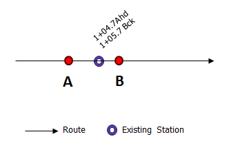
Assume that you have to enter a From measure value of 1+04.8 in the Station parameter. You'll have two options to locate that measure. The first option is to locate it using the Ahead station value of 1+04.7, and the second option is to locate it using the Back station value of 1+05.7.
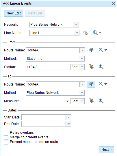
In this case, a pop-up appears so you can select the location of the measure from the two available options.

The first option is to choose measure 104.8 (measure on route), which is shown by B above; this location is calculated using the Ahead station value. The second option is to choose measure 103.8 (measure on route), which is shown by A above; this location is calculated using the Back station value. The proposed From measure location of 1+04.8 is closer to the Ahead station value of 1+04.7 when compared to the Back station value of 1+05.7; therefore, point B is located closer to the station compared to point A.