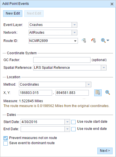
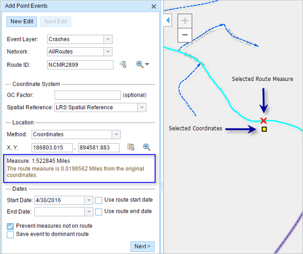
Point events such as crashes and traffic count sites can be represented as a single point event with measure information along the route. The Add Point Events widget allows you to create point events by typing or selecting their x- and y-coordinates.
- 打开 Event Editor 并在出现提示时登录到您的 ArcGIS 组织。
- 单击编辑选项卡。
- 在编辑事件组中,单击点事件按钮
 。
。随即显示添加点事件微件。
如果没有可编辑的点事件图层,则该微件将被禁用。
- 从事件图层下拉列表中选择要编辑的事件图层。

- Click the Network drop-down arrow and choose the network that will serve as a source for providing the measure for the new point event.
- Type a route ID in the Route ID text box on which the new event measure will be based.
提示:
也可以单击在地图上选择路径按钮
 以在地图上选择路径。
 - Optionally, input a value in the GC Factor text box.
This will adjust the coordinates by dividing x and y by the value specified for GC Factor.
- Choose a coordinate system from the Spatial Reference menu options.
- LRS Map Service—The spatial reference of your LRS network
- Web Map Spatial Reference—The spatial reference of your basemap
- GCS_WGS_1984—A geographic spatial reference using units of degrees
Additionally, you can configure different coordinate systems by specifying the Well Known ID (WKID) or Well Known Text (WKT) in the configuration file of your Event Editor.
注:
If your event stores referents, the referents will be stored in the coordinate system of the event feature class.
- In the Location section, click the Method drop-down arrow and choose Coordinates.
The Coordinate System section appears.
- Input the x- and y-coordinate values for X and Y.
提示:
You can also select a coordinate by clicking the Select an X/Y Location on the Map button.
- 单击开始日期和结束日期日历控件以选择事件的开始日期和结束日期。
开始日期默认为今天的日期,也可以使用日期选择器选择不同的日期。 结束日期也可选。
注:
如果将 Event Editor 实例配置为不允许输入路径开始日期之前的日期,那么当您在开始日期中输入所选路径开始日期之前的日期时,将出现一条警告消息,提醒您选择一个位于所选路径开始日期当天或之后的日期。

- 单击下一步以查看属性值表。
此表包含所有的事件图层属性。
注:
配置属性值表中的任何字段时,支持编码值属性域和范围属性域以及子类型。
- 在表中提供新事件的属性信息。
提示:
可以单击复制属性值按钮
 并单击地图上属于同一事件图层的现有点事件以从该点复制事件属性。
 - 选中显示网络名称复选框以显示与选定事件图层关联的 LRS 网络。
- 单击保存。
新添加的点事件保存后,将在右下角显示一条确认消息。 新的点图层将创建并出现在地图中。
成功创建事件后,您有以下两个选项来继续表征路径:
- 单击新建编辑以清除微件中的所有输入条目并将默认值从地理数据库恢复到属性表。
- 单击下一编辑可以保留小部件和属性表中的所有现有条目,以便于快速编辑相似的特征。