What is a data store?
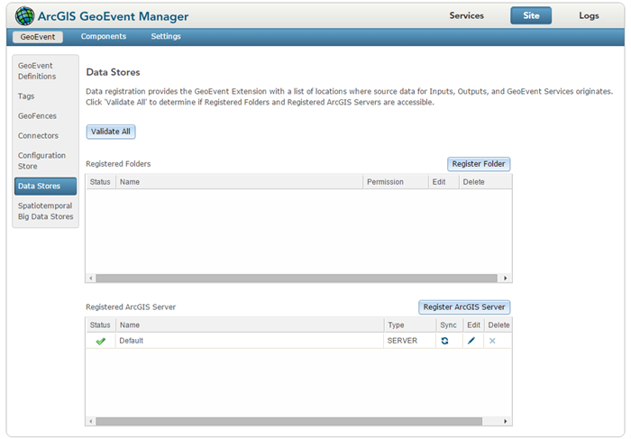
Data stores provide the Erweiterung "GeoEvent" with a list of locations where source data for inputs, outputs, and GeoEvent Services originates. Folders and ArcGIS Server connections are examples of data stores that can be registered with the Erweiterung "GeoEvent". Register and validate data stores by browsing to the Site > GeoEvent > Data Stores page in GeoEvent Manager.

Registered folders
The Erweiterung "GeoEvent" requires system folders containing GeoEvent Service input or output files to be registered, for example:
- A GeoEvent Service configured to watch a folder for new CSV data files requires a registered folder to be specified so the Erweiterung "GeoEvent" knows which folder to poll for new input files.
- An Output Connector configured to log event data as CSV text requires a registered folder to be specified so the Erweiterung "GeoEvent" knows where to create the output file.
When a system folder is successfully registered, a green check mark will appear next to the folder in the Registered Folders window. This indicates the Erweiterung "GeoEvent" has access to the folder. To validate registered folders, click Validate All on the Data Store page in GeoEvent Manager.
Registered ArcGIS servers
The Erweiterung "GeoEvent" requires connections to ArcGIS Server to be registered. This provides administrators with an opportunity to provide connection credentials, if credentials are required to access secured service folders or services. A local ArcGIS Server site is one example of an ArcGIS Server connection that can be registered with the Erweiterung "GeoEvent". An ArcGIS Online account is another example of an ArcGIS Server connection that can be registered with the Erweiterung "GeoEvent".
- The Erweiterung "GeoEvent" can add new features to (or update existing features in) a published feature service once the ArcGIS Server connection has been registered.
- Published feature services can also be used as the source of GeoEvent Definitions or GeoFences.
- Processors within a GeoEvent Service such as the Field Enricher (Feature Service) Processor require the GeoEvent Service being referenced be accessible through a registered ArcGIS Server connection.
When an ArcGIS Server connection is successfully registered, a green check mark will appear next to the folder in the Registered ArcGIS Server window. This indicates that the Erweiterung "GeoEvent" has access to ArcGIS Server using the provided credentials. To validate registered folders, click Validate All on the Data Store page in GeoEvent Manager.