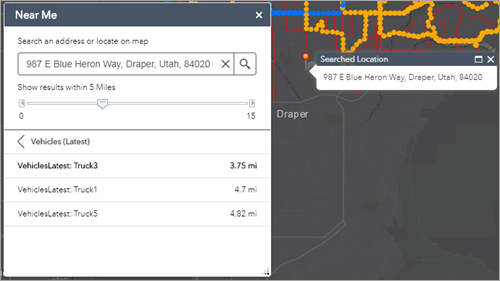
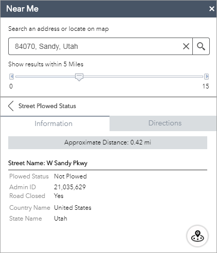
The Near Me widget allows you to find features within a buffer of a defined address or location, view detailed information about those features, and get directions to the selected feature.
Additionally, the Near Me widget can be configured to find polygon features containing a defined address or location instead of polygon features within the buffer.
Caution:
You may notice the difference in buffer operation from the Measurement widget. This is because the Near Me widget uses a Euclidean buffer (planar) by default and has an option to choose a geodesic buffer. The Measurement widget, however, defaults to a geodesic buffer with no options.
Configure the Near Me widget
This widget can be set to open automatically when
an app starts. To enable this feature, click the Open this widget automatically when
the app starts button  on the widget, which turns it dark
green.
- Hover over the widget and click the Configure this widget button
 to open the configuration properties dialog box.
 - Optionally click Change widget icon and replace it with your own image.
A file explorer window appears, allowing you to select a local image file to use as the widget icon.
- To configure the Search Source Settings section, see the Search widget topic. The Near Me widget follows the same configuration steps.
- In the Search Settings section of the widget configuration, specify the following options:
- Search font color for search results—This is the color displayed in the title section of the search results.
- Select search layer(s)—Select a layer or layers to be configured in the widget.
Note:
Search layers must have a pop-up configured.
- Set Location Button—Enable this option to display the Set Location button next to the search box. Click the button and click the map to set the search location. If you do not enable this option, clicking the map will automatically set the location.
- Only draw selected search layer results—Enable this option to only display features of the layer selected in the listed search results.
- Set buffer visibility—Enable this option to display the buffer.
- Set buffer distance—Define the default value of the buffer slider.
- Set maximum buffer distance—Define the maximum value of the buffer slider.
- Buffer distance units—Define the units used by the buffer slider, such as miles, kilometers, meters, or feet.
- Limit number or results—Specify the maximum number of results to return.
- Use geodesic buffer—Enable this option to generate a geodesic buffer instead of a Euclidean buffer (planar).
- Address or location symbols—Select and adjust the symbols used to mark the search location.
- Zoom to selected feature—Enable this option to zoom to the selected feature and set a location instead of the buffer.
- Return intersecting polygon(s)—Enable this option to return the polygon or polygons containing the searched location rather than polygons within the buffer.
- Optionally, in the Directions Settings section of the widget configuration, set up the widget to use routing, which allows you the option to get driving directions to the selected feature.
License:
ArcGIS Online network analysis services require an ArcGIS Online for organizations subscription. If you choose to work with this, specify a valid user name and password for ArcGIS Online. Each successful request to the service incurs service credits from your subscription. In addition, if you have ArcGIS Server network analysis services, you can also specify the URL.
Tip:
If you want to share your secure service item with the public, for example, as part of a public web app, store the credentials with the item so the public is not required to log in to get to your app. See ArcGIS Server web services for more information.
- To configure the Directions Settings section of the widget configuration, specify the following options:
- Routing Service—Click Set and browse to a routing service in your ArcGIS Online organizational account, or provide the URL to the routing service.
- Direction length units—Select the units used to display directions (kilometers or miles).
- Select symbol to display route—Select the display symbol, color, style, transparency, and width to be used for the route.
- Use graphics to represent attribute values, such as pictographs for the amenities that are available at a facility. Configure these graphics in the Symbology Settings section of the widget configuration by specifying the following options:
- Click Add New Symbols to add a new symbol.
- Choose a layer, field, and value for that field to represent with a graphic.
- Choose a symbol to represent that value in that field and that layer. This graphic will display in the Near Me panel below the pop-up attributes and above any attachments. The graphic representation of the attribute will display even when the attribute is hidden in the pop-up.
- To remove a graphic, click the x under the Actions column.
- Allow your users to filter the search results to help them find the right information. Configure these filters in the Filter Settings section of the widget configuration by specifying the following options:
- Click New Filter to define a new filter.
- Choose the search layer that will be filtered by these settings. Only layers selected on the Search Settings tab are available when configuring a new filter.
- Name the filter in the Title text box.
- Browse to your local images to choose an icon for the filter. The default icon will apply if you don't specify it.
- Optionally click the box next to Remove the preset layer filters from the map if you don't want to carry over the filters in the map to your app.
- Click Add a filter expression.
- Click the field drop-down arrow and choose the field you want to filter against from the list.
- Click the operators drop-down arrow and choose an operator from the list.
- If you want to filter based on a specific value, choose Value and enter a value in the field. Check the box to the left of Ask for values if you want to set up an interactive expression. Enter information about the value in the Prompt field and a hint in the Hint field.
- If you want to compare the value in one field to the value in another field, choose Field, click the drop-down arrow, and choose the field for your expression.
- If you want to filter based on a specific value in the field you've selected for your expression, choose Unique and select a unique value from your field. You can also dynamically show the values based on the previous expressions or all other expressions regardless of their orders. Enter information about the value in the Prompt field and a hint in the Hint field, and select how the values are listed.
Caution:
Unique value filters require a 10.1 or later map service layer. The Unique option does not appear if you are creating a filter on a 10.0 or earlier service layer.
Caution:
To display a description for coded values when Values filtered by previous expressions or Values filtered by all other expressions is selected, the service must support the capability of query by statistics.
Note:
If you created an expression based on values or a unique value, you can set up an interactive expression by clicking the box to the left of Ask for values. You cannot ask for values on expressions based on a field.
- To create multiple expressions, or one or more sets of expressions, click Add a filter expression or Add an expression set.
A set is a grouping of expressions, for example, Shelter capacity is greater than 200 and Status is open.
- To add another filter, repeat steps a through g.
- Hover over the filter you created in the table to delete or order it.
- Check the Collapse the filter expression (if any) when the widget is opened option to collapse the filter with Ask for values.
- Check the Group filters by layer option to sort the filters by the layer they impact.
- Click OK to save and close the configuration.
Note:
The widget uses many different elements from the map used in Web AppBuilder for ArcGIS. The list of features displays the layer names in the map, the results of each layer display from the pop-up title of the map pop-up, and the information panel displays the map pop-up.Tip:
Routing is enabled and disabled in the application settings of the ArcGIS Online item page of the map used by the widget. If you see the message To enable directions, ensure that routing is enabled in the ArcGIS Online item on the Directions tab and you want to enable directions, go to Application Settings on the item details page of the map you are using, recheck the routing application setting, and save the map. See Set map options for apps for more information.Use the Near Me widget
- Click the Near Me widget icon to open it.
- Define the area you want to buffer by adjusting the slider to the desired number.
- Search for an address in the search bar or click a location directly on the map to define the location to be buffered.
You will see a list of the features found within the defined buffer for each layer as well as a count of how many features belong to each layer.

- Click a layer in the list of results and click the desired feature.

You will see information about the feature on the Information tab.
- Click the Directions tab if the widget is configured to provide driving directions. It will provide you with driving directions to the selected feature from the defined location.