About registering your data with ArcGIS Server
In this topic
- Data sources you can register
- Before registering data
- Scenarios for registering your data
- How to register your data with ArcGIS Server
As an ArcGIS Server administrator, you have the option to register your data folders, databases, and geodatabases with ArcGIS Server. Data registration provides ArcGIS Server a list of locations to access. Data registration also helps ArcGIS Server adjust data paths when publishing across machines.
Suppose you're a server administrator and you have a department of GIS analysts who will be publishing services to your server from different machines. Using the system tools in ArcGIS for Desktop, you could register a set of approved folders and databases with the server and communicate these directories to your analysts. By using this method, you can decrease the number of incidents where your analysts encounter permissions problems and are unable to publish to ArcGIS Server.
Data sources you can register
You can register any of the following with ArcGIS Server:
- Databases accessed through a database connection file (.sde only); this includes databases that contain a geodatabase and those that do not
- Database tables accessed through an OLE DB connection file (.odc)
- Folders containing file-based data; this includes shapefiles, file geodatabases, and other GIS resources
You can register any enterprise database compatible with ArcGIS by referencing the database connection file (.sde file). The database you connect to can contain an enterprise or workgroup geodatabase, but it doesn't have to.
You can also register a database with the server by referencing an OLE DB connection (an .odc file). OLE DB connections provide uniform access to data from a variety of database sources, but are nonspatial connections.
You can also register local and shared operating system folders with the server. These can contain shapefiles, file geodatabases, and other GIS resources. When you register a folder, its subfolders are also registered.
Note:
If your data locations change, you should update your registered data locations using ArcGIS for Desktop or ArcGIS Server Manager.
Before registering data
Registering your data does not grant the ArcGIS Server account permissions to access your data. Before registering your data, you'll need to ensure that the ArcGIS Server account has at least read permissions to the data stored in folders, in databases, or in enterprise or workgroup geodatabases that are accessed using operating system authentication. To learn more about this process, see Make your data accessible to ArcGIS Server.
If you'll be registering an enterprise geodatabase or database (a .sde or .odc file) with ArcGIS Sever, you'll also need to ensure that the 64-bit version of the database's client software is installed on each GIS server in your site. For example, if you plan to register a SQL Server database, you must install SQL Server Native Client on each GIS server in your site. Keep in mind that once you've installed the client software, you'll need to restart the ArcGIS Server service.
The following links describe the client software needed for each database, how to grant the ArcGIS Server account data access privileges, and how to connect to the database:
- Register ALTIBASE with ArcGIS Server
- Register a DB2 database with ArcGIS Server
- Register an Informix database with ArcGIS Server
- Register a Netezza database with ArcGIS Server
- Register an Oracle database with ArcGIS Server
- Register a PostgreSQL database with ArcGIS Server
- Register SAP HANA with ArcGIS Server
- Register a SQL Server database with ArcGIS Server
- Register a Teradata database with ArcGIS Server
- Register a workgroup geodatabase with ArcGIS Server
Scenarios for registering your data
Before registering your data, examine the following scenarios and consider how your workflows relate:
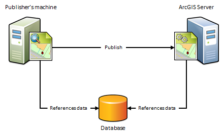
The publisher's machine and the server are working with the same database
If the publisher's machine and the server are working with the same database, import the publisher's database connection and set the server's database connection to Same as publisher's connection when registering your data.

When to use this scenario
Use this scenario if you want to avoid having a copy of the data placed on the server. For example, suppose you want to publish a map service to ArcGIS Server using data from an on-premises enterprise geodatabase. To avoid having a copy of the data referenced by your map document placed on the server, import the publisher's database connection and set the server's database connection to Same as publisher's connection. After you publish, the map document continues to reference the data stored in your enterprise geodatabase.
When not to use this scenario
- If your data resides in a file geodatabase or file directory. Instead, use the next scenario.
- If you want to maintain a separate copy of the data in your enterprise geodatabase for web use.
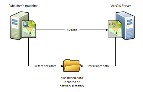
The publisher's machine and the server are working out of the same folder
If the publisher's machine and the server are working out of the same folder, specify the publisher's folder path and set the server's folder path to Same as publisher's path when registering your data. This scenario is just like the previous one, except it uses folders, not databases.

When to use this scenario
Use this scenario if you want to avoid having a copy of the data placed on the server. For example, suppose you want to publish a geoprocessing service to ArcGIS Server using data from a network directory. To avoid having a copy of the geoprocessing service's data placed on the server, specify the publisher's folder path and set the server's folder path to Same as publisher's path. After you publish, the geoprocessing service continues to reference the geoprocessing model, inputs, outputs, scripts, and project data stored in your network directory.
This scenario is also beneficial if you have a Linux-based ArcGIS Server site that manages all of your data and you've set up Samba to allow file sharing between Windows and Linux. For example, if you want to publish a map document that references the data on your Linux machine, register the Samba directory (\\net\data) as the publisher's folder and register the Linux directory (/net/data) as the server's folder. When you publish, the map document is automatically modified to reference the directory on the Linux machine.
When not to use this scenario
- If your data resides in a database. Instead, use the preceding scenario.
- If you want to publish feature or WFS-T services.
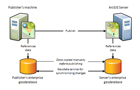
The publisher's machine and the server are working with different databases
Because of firewalls, differences between computing platforms, or the desire to keep a separate copy of the data for web use, the publisher and the server may each be working with different databases. To register your data using this scenario, you'll need to import both the connection to the publisher's database and the connection to the server's database.

When to use this scenario
Use this scenario if you want to maintain a separate copy of the data in your on-premises enterprise geodatabase for web use. In this case, you're responsible for making sure a copy of the data in your publisher's geodatabase exists in the server's geodatabase. This scenario can only be used with enterprise geodatabases; not databases.
One way to get your data into the server's enterprise geodatabase is to check Create geodata service for server database when registering your enterprise geodatabases. Selecting this option automatically creates a geodata service that you can use to manually send a replica of the data in the publisher's geodatabase to the server's geodatabase.
You can also use the geodata service to synchronize the enterprise geodatabases, thereby ensuring that any subsequent changes made to the publisher's database are reflected in the server's database. This is particularly advantageous in cloud deployments, such as ArcGIS Server on Amazon Web Services, as it does not require someone to log in to the cloud machine and arrange for the data transfer.
This scenario is also well suited for publishing feature services to on-premises or cloud servers. For example, if you publish a feature service using this scenario, edits made on-premises could be pushed to the server's geodatabase, thereby becoming available to end users of your feature service. Conversely, if web editors change any features in the server's geodatabase, the edits can be synchronized with the publisher's geodatabase.
When not to use this scenario
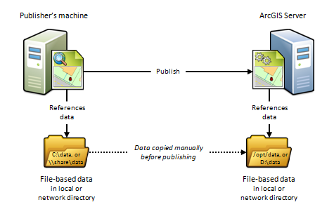
The publisher's machine and the server are working out of different folders
Because of firewalls, differences between computing platforms, or the desire to keep a separate copy of the data for web use, the publisher and the server may each be working with their own data folder. To register your data using this scenario, you'll need to enter the path to both the publisher's folder and the server's folder.

When to use this scenario
This scenario is useful for Linux deployments, cloud deployments, or any deployment where you want publishers and web users to work with separate copies of the data.
For example, if you want to publish a map service from ArcGIS for Desktop to a Linux-based ArcGIS Server site, you could create an identical copy of your map document's data and place the data on the Linux-based server. After you register both directories with the server and publish, the map document is automatically modified to reference the folder on the Linux-based server.
This scenario is beneficial if you are publishing to a cloud-based server such as ArcGIS Server on Amazon Web Services. For example, you can copy your on-premises data and place it in any directory you want to in the cloud. When you publish, the data paths are automatically modified to reference the directory on the cloud server. The disadvantage of this approach is that it requires someone to log in to the cloud machine and arrange for the data transfer to the cloud (which could be performed through FTP, remote desktop copy and paste, or other supported data transfer methods).
When not to use this scenario
How to register your data with ArcGIS Server
You can register your data folders and databases withArcGIS Server using ArcGIS Server Manager or ArcGIS for Desktop. For full instructions, see the following: