Make your first scene
In this topic
A scene is symbolized 3D geospatial content that includes a multiscale basemap, a collection of 2D and 3D layers, styles, and configurations that allow you to visualize and analyze geographic information in an intuitive and interactive 3D environment.In Portal for ArcGIS, you create interactive scenes with the built-in scene viewer. Sign in to the portal to create scenes.

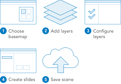
1. Choose basemap
A basemap provides a background of geographical context for the content you want to display in a scene. When you create a new scene, you choose which basemap you want to use from the collection in the basemap gallery. Show me how.
2. Add layers
Layers are the contents of your story. They can include topics related to people, the earth, life, and imagery. You can add your own layers and layers shared by others. Show me how.
3. Configure layers
Configure layers to improve the presentation of your data. Depending on your layer, you can change symbols by size, type, and color. Show me how.
4. Create slides
Slides present specific views of your scene. Create slides to preserve multiple views of the same scene. Show me how.
5. Save scene
Save your scene to My Content so you can return to it later and share it with others. Show me how.